
The Churches of Curahuara de Carangas and Sajama: In and Near Sajama National Park

Capilla de Ojsani
This is the second of two posts that serve as the “backbone” of my Guide to the Churches of Curahuara de Carangas and Sajama. This post provides directions to the churches and other sites in and near the Sajama National Park, as well as links to descriptions of each of the sites. The guide is written from the perspective of someone traveling from Curahuara de Carangas, but should be easy to “turn around,” by reading this page from the bottom up and visiting the sites in reverse order. The first of these two posts is The Churches of Curahuara de Carangas and Sajama: La Paz to Curahuara de Carangas.
This post starts where the first post ended, at the turnoff to Curahuara de Carangas from the La Paz-Arica Road. Some 7.5 miles beyond the turnoff to Curahuara de Carangas is another small road to the left which takes you to Qilqata Chapel, visible from the road.

Nevado (or Tata) Sajama, in the distance
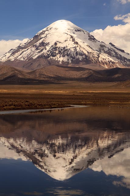
You’ve been seeing Tata (father) Sajama, the highest peak in Bolivia, for much of the trip, but as you continue on from Kellkata, Father Sajama, worshipped as a god by the locals even today, looms up increasingly large in your windshield.
Sajama stands in solitude on the altiplano, apart from its brothers of the western Andean chain some ten miles further west, and our route will take us all the way around the mountain, giving you many different views of all the faces of this impressive 21,463 foot stratovolcano.
Another 11.3 miles further you will come to an intersection, Cruce Okoruro (labeled as such on the map and in the .gdb file). A road turns off to the right from the main road. This is the old road to Arica. I traveled it back in 1988 before the new paved road was built. In fact, I got stuck in the mud somewhere near this turnoff. In rainy weather, this road may still be impassible. However, in good weather this is definitely the better route to Tomarapi, as you pass by several chapels on the way and through some very interesting country. Be careful with this turnoff, though. There are several roads turning off, only one of which will take you to Tomarapi, and none of them are marked. The right road turns immediately into a set of huge hoodoo rocks. You’ll see them from a distance, as they stand on top of a ridge, so that is your cue to turn, if you are not using a GPS (which I strongly recommend).
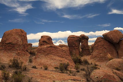
Hoodoos with Tata Sajama in the background
Shortly after your turn you may want to get out and take a walk among the hoodoos. Hoodoos are one of the small connections that seemingly link Bolivia with my home state of Utah. The word is sometimes used to refer to people who practice a type of African-American spiritualism akin to Voodoo. When early settlers to the western U.S. found the strange rock formations which sometimes look like statues of people with a large hats they variously called them “goblins” and “hoodoos,” and both names are still used today. In fact, a favorite place of mine in Utah is Goblin Valley State Park, with its extensive concentration of hoodoos.
The hoodoos are common for the first couple of miles down the road to Tomarapi. At about four miles, you will come upon the Ojsani Chapel, on the left side of the road. Another 4.2 miles down the road, you will come upon a track off to the left, which goes to the ruins of the Kellua Kota Chapel, just two miles off the main road.
From the turnoff to Kellua Kota Chapel, it is another 2.7 miles to the turnoff on the left to Estancia Khotasaya and the Khotasaya Chapel. From that turnoff, it is yet another 5.4 miles to Tomarapi.

Tomarapi Chapel in the evening
Albergue Tomarapi is probably your best bet for a place to stay in Sajama National Park. It is a community-run albergue, or shelter, a cute place to stay with small, clean, functional (but very cold) rooms, showers, and a small cafe/restaurant. If you are planning to stay there, you might do well to make a reservation. Not that it is often full, just that if you are unlucky and they don’t have room, there is pretty much nowhere else to stay.

Vicuñas in the foothills of the Sajama
By the time you are in Tomarapi, you have already entered the Sajama National Park. The park is intended to protect Tata Sajama and the area around it, an area of particular, if austere, beauty. From Tomarapi, our route now takes us on a loop around the lonely mountain Sajama, isolated as it is on the altiplano from the Andes range some ten miles to the west. After leaving Tomarapi, you will pass by Laguna Huana Khota on your right. This reservoir is habitat for numerous waterfoul and herds of llamas, alpacas and vicuñas are often seen nearby. You should have seen plenty of vicuñas by now, and will continue to see them throughout the park and beyond.
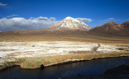
The Hot Springs
Some five miles from Tomarapi a track splits off to the right. If the weather is dry, this road makes a nice loop up away from the mountain for some nice vistas across the bofedales (high altitude wetlands that serve as pasture for the llamas, alpacas, and vicuñas). It comes back down to the main road some 4.2 miles on, but the loop itself is longer, running almost twice that distance. This loop road runs past the hot springs, Termas Manasaya, where you should definitely stop for a dip in the hot water. The springs are only about a mile-long cross-country walk from the main road, and can also be reached from the other end of the loop road by turning in for about 1.5 miles at about 9.3 miles from Tomarapi.
The national park area is sparsely enough inhabited to allow for a lot of native wildlife. Besides the numerous birds and camelids, I have even seen an Andean Cat run across the road. I considered that to be a true privilege, as not many Bolivians have seen an Andean Cat. One one of our trips out to the park we also had the luck to come upon a vicuña roundup in progress. As vicuñas cannot be domesticated and their wool is very valuable for its softness and warmth, the locals round them up every so often and sheer them, freeing them again afterwards.
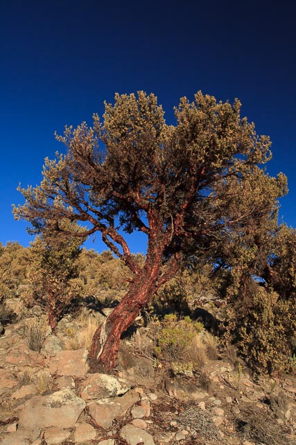
A Queñua Tree, growing on the side of the Sajama
While you are in the Sajama area, you are going to want to hike up the mountain, at least a bit. The lower slopes of the mountain are forested exclusively with the queñua tree, in what is reputed to be the highest forest in the world, growing at over 14,000 feet of altitude. The tree line on the Sajama, considered the highest tree line in the world, is at 17,100 feet of altitude. In contrast, in no other place on earth do trees grow naturally at an altitude of 14,000 feet, the base altitude of the queñua forest. (For comparison sake, the other highest tree lines in the world are: 13,800 ft., Khumbu, Himalaya, 13,500 ft., Eastern Cordillera of the Andes, Bolivia, 13,100 ft. Pico de Orizaba, Mexico, and 13,000 ft., Mt. Kilimanjaro, Tanzania. In the U.S. the tree line never exceeds 12,000 ft.) I hiked up the mountain for a few hours following one of the trails used by climbers of the mountain, but there are many other alternatives. This trail can be reached by turning left off the main Tomarapi-Sajama road some nine miles from Tomarapi and only about 1500 feet from the right turnoff onto the loop road and to the hot springs.
From the second junction of the loop road with the main Tomarapi-Sajama road, it is only 2.2 miles to the village of Sajama and the Sajama Chapel. Passing back through Sajama village there is another road running towards the northwest. This is the road to the geyser field, some 4.5 miles away, another must-see site in Sajama National Park.
Tata Sajama Reflected in Laguna Isla, near Lagunas
Continuing along the main road past Sajama, in about seven miles you will come again to the La Paz-Arica road. Take a right turn here for the short jaunt (1.5 miles) to Lagunas, where the last of the chapels on our list stands. From Lagunas, you can also continue on to Chile, visiting Lago Chungara and the Lagunas de Cotacotani in Sajama’s Chilean sister park, the Lauca National Park.

Lagunas de Cotacotani, with the Twin Volcanos Pomerape and Parinacota in the Background, Parque Lauca, Chile
While you are in the area, you would also be well advised to check out the Chulpas Polichromas, some 43 miles south of the La Paz-Arica road. To get there, take the last left before Tambo Quemado and the Chilean border.
The return trip to La Paz can be taken quickly on the La Paz-Arica road.
Posted: February 15th, 2016 under Altiplano, Archeology, Bolivia, Chile, Churches, Day Trip, GPS, Hiking, Mapping, Sajama National Park, South America, Travel.
Tags: Altiplano, Bolivia, Churches, Day Trip, GPS, Hiking, Mapping, Travel
Comments
Pingback from Larry Memmott's Blog » The Churches of Curahuara de Carangas and Sajama: La Paz to Curahuara de Carangas
Time February 18, 2016 at 9:06 pm
[…] After visiting Quilviri, you can pick up the second half of the circuit in The Churches of Curahuara de Carangas and Sajama: In and Near Sajama National Park. […]
Write a comment
You need to login to post comments!
Pingback from Larry Memmott's Blog » The Churches of Curahuara de Carangas and Sajama: An Exploration
Time February 18, 2016 at 9:06 pm
[…] Sajama: La Paz to Curahuara de Carangas for the first half of the trip (leaving from La Paz) and The Churches of Curahuara de Carangas and Sajama: In and Near Sajama National Park for the second half (or traveling from the Chilean […]