Site menu:

Comanche and the Queen of the Andes

Puya Raimondii, just after flowering, December 2013

Puya Raimondii, just after flowering, December 2013

We enjoyed a glorious day on the Altiplano on Sunday.  Our plan was to drive a loop south of La Paz, visiting several colonial-era churches, a mining town, and some Inca and Pre-Inca ruins as well as Comanche and the famed Queen of the Andes.  In fact, we had such a good time in Comanche that we got no further.

I have probably already lost a few of you.  First, Comanche.  The Hacienda Comanche belonged to the Machicado family from 1906.  Unfortunately, the status of the property, and especially of the Casa Grande, is currently contested, like many properties in Bolivia. It sits on the railroad line from La Paz to Arica, so is sometimes called Estacion Comanche.  Near the train station and the newly asphalted road is the Casa Grande of the Hacienda, built by the Machicados in 1910 in an Italian baroque style and still mostly standing.  Hidden off to the side is the village, with its granite church.

The Train Station

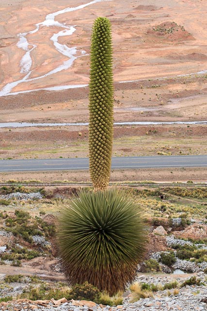
Then there is the Queen of the Andes, also known as the Puya Raimondii.  The Puya Raimondii is the plant with the largest flower of all.  A bromeliad endemic to only small regions of Peru and Bolivia, the sword-like leaves form a main growth of the plant which can extend to three meters in height (and width, since it is spherical in shape).  However, the flower, or inflorescence, which appears only after some 40 years of growth, shoots up to as much as ten meters in height.  After the plant flowers, it dies, and, strangely, seems to burn itself black.  The inflorescence of a single plant may display more than 3,000 individual flowers and produce six million seeds.  The Puya flowers in the spring, sometime between September and November.  Unfortunately, though, there are no plants flowering this year.  The locals say next year is a sure thing.

Tatyana and a Puya Raimondii

With such a prodigious display of reproductive power, one might expect the Puya Raimondii to be thriving.  However, though it may have existed as long ago as the time of the dinosaurs, it is having a tough time now.  Considered endangered, it grows only in very small areas of Peru and Bolivia.  In Bolivia, only the hill next to the town of Commanche and one square kilometer of land in the Vacas Municipality of Cochabamba host the Puya.  Why it does not spread is a mystery.

Aliciya and Puya

Comanche is known for another product, as well.  The granite which serves as cobblestones throughout Sopocachi and other parts of La Paz comes from the quarry which shares the Comanche Hill with the Puya.  In fact, the U.S. Embassy in La Paz is also made from Comanche granite, a source of pride for the locals.


It’s also a good place (of course there are many good places) to watch the viscachas play.

We saw lots of viscachas playing among the rocks and the puyas

The timing of our visit to Comanche was propitious.  We arrived on the day that the local community had selected to do their challa (sacrifice or prayer) to the Pachamama (Mother Earth/Mother World) to ask for success in the new tourism venture they were undertaking.  When we were about halfway up the hill, the locals started up.  Though they stopped every so often (they had a band with them and would stop to play a while) they soon passed us by.  When we got to the top of the hill, they were just starting the ceremony.

A holy man built a fire from the dried dung of animals and laid out the items to be sacrificed, mostly food items and including, prominently, both alcohol and coca leaves.

With the small fire blazing, we all got on our knees and he offered a prayer in Aymara.

He then lifted the offerings and, one by one . . .


. . . placed them into the flames.

He then took a bottle of alcohol and poured a bit onto each of the four “corners” of the fire.

The four “corners” or directions are very important in Aymara cosmology. If I understand correctly, they represent the four major regions of the Inca Empire, the Contisuyo, Collasuyo, Antisuyo and Chinchasuyo.

With the fire burning higher . . .

. . . the holy man offered each of the participants, myself included, the opportunity to “challar,” tossing a little bit of alcohol onto each of the four corners of the fire.

Once the ceremony was concluded, the band struck up a tune and everyone started to dance.  I got some good photos of the

youngsters dancing before being pulled into the dance myself by one of the cholitas.  Aliciya and I danced with the group until the dance broke up, after which Aliciya and I went with some of the youngsters to climb around on a pile of rocks near the ceremonial ground.


The locals invited us to participate in the meal they had prepared and laid out in the Casa de Hacienda (Ranch House) below.  Not surprisingly, they had to wait for us for lunch as Aliciya was the only one of us who was able to even come close to keeping up with the locals on the way down.

We enjoyed a delicious and interesting meal of llama meat, both freshly fried and jerked, white corn, quinoa soup, chicken, chuño, baked local potatoes, and hard boiled eggs.  Our hosts were only too happy to show us the textiles they are producing from alpaca wool and the items they are carving from the granite, as well as some early pottery work they are doing (but they lack an oven for glazing it).  All in all, it was a great, and extremely interesting day.  What’s more, they are looking to attract people to their town to experience the same, so now it’s your turn!

We have visited Comanche several times since that, most recently in December, 2013.  At that point, we were just a week too late to see the Puyas in bloom, a shame, since at least six bloomed that year.  Here is a photo of just the inflorescence of one of them.  If you look carefully at the top, you might see just a bit of the remains of a few of the 3,000 flowers that were there a week earlier.

Top of the inflorescence of one of the puyas that bloomed in December, 2013

Top of the inflorescence of one of the puyas that bloomed in December, 2013

Getting to Comanche

With the recent completion of the paved road to Comanche, this is a pretty easy trip.  (One bridge is not finished, so one small stream must be crossed at a ford, but it should not be much of a challenge, even for a sedan.)  To get there, head south from El Alto on the Carretera La Paz-Viacha (19).

Road to Comanche – Click to enlarge

It’s a straight shot to Viacha, and through Viacha you also need to go straight, though some turns are inevitable. You’ll know you’ve found the right way when, as you leave town, you cross over a cute, one lane, stone bridge.

Viacha – Click to enlarge

From Viacha, the road continues on pretty straight.  It is mostly a newly paved road in very good condition.  At about 18 miles from the center of Viacha, there is a turn off to the right, but you want to keep to the new road on until you arrive at Comanche.

Here is a .gdb file you can use in your GPS or open in Google Earth to see the route in greater detail.

The Hike

It’s a short hike, only 0.65 miles, though it is a bit steep.  From the front of the hacienda house, circle around to the right and follow the well trodden path.  You climb almost steadily from 13,283 ft above sea level to 13,787, for a total climb of some 500 ft.  It took us an embarrassing hour and a half to get up, but I’m attributing that to Aliciya’s determination climb across the rocks on the sides of the path rather than walking along the “boring” path.  The hike is also covered in the .gdb file.

Contact Information

While you can have a nice (short) hike and view the puya raimondii without making any previous arrangements, the locals would be happy to host you for events similar to what they put on for us.  I’ll get information on how to set that up and put it here within the coming days.

More Photos

I took a lot more photos If you would like to see some of the highlights, go to http://larrymemmottphotography.com/portfolios/comanche/.


Bolivia Is Waiting for You

That’s the English translation of the theme of the new Bolivian tourism campaign (Bolivia te espera). Take a look at the ads. They may be a bit repetitive, but they give you a good idea of some of the beauties of Bolivia.

[youtube]http://www.youtube.com/watch?v=goR8GRPlLbE&feature=youtu.be[/youtube]

[youtube]http://www.youtube.com/watch?v=P2rRn7ZurvI&feature=youtu.be[/youtube]

[youtube]http://www.youtube.com/watch?v=bXI5SPaM_s8&feature=youtu.be[/youtube]

[youtube]http://www.youtube.com/watch?v=Lu-1L8fkvv8&feature=youtu.be[/youtube]

Valley of the Moon

The valley of the moon is one of the closest and easiest trips out of La Paz. In fact, these days it is hardly even out of La Paz, as the south zone of the city (Zona Sur) continues to creep down the valley. The formation is of heavily compressed dirt and clay, which has weathered into formations reminiscent of sandstone formations in the U.S. Southwest.

It’s pretty easy to get to Valle de la luna. Basically, you just have to keep going down the valley from La Paz until you get there. However, in case it would be helpful, here is a map and .gdb file for use in your gps (and here and here are two links for using them).

(click image to enlarge)

As easy as it is to get there, Valle de la luna is also a lot of fun. It’s not big, but there are a couple of short hikes you can take through the strange formations, and though you could easily walk the whole thing in an hour, you could also stroll though it for a good two or three hours, without getting bored. As you can tell from the photos, we did the walk at mid-day, but to really see it well, I would suggest getting there in the morning or going a bit later in the afternoon when the light is better. We will definitely be going back sometime.

La Paz

_MG_8724

Bolivia is beautiful, no doubt about it.  This is just the view from the bedroom window of our temporary house.

Orto Say

Though I’ll call this a day trip, you can actually visit this field of wildflowers on your lunch hour.  I’m not certain that it is actually in Bishkek proper, but if not, it is just outside.  Really, it is just an example of many beautiful places you can find by exploring the near foothills.

This is also a loop, though I have only traveled the backside of the loop, so I’ll give no guarantees.  The final part of the road is dirt, and likely mud when wet, so although a car could probably make the trip in dry weather, you should be wary about the possibility of getting stuck. This ride could easily be combined with a visit to the memorial at Ata Beit.

As the .gdb file shows, the trip, in either direction, begins by driving out to the final intersection at the south end of Mir Avenue.  From here, the closer route turns left.  In another 1.5 miles, turn right.  From here on out, I don’t know how to give you directions, so see the .gdb file on Google Earth or your GPS.  Of course, any of the jeep trails wandering through these hills might take you to an even more magical place than I found. What’s more, the flowers probably vary from year to year, and from week to week.

The back route involves driving towards Ala Archa until you come to the major intersection (with the arch).  There, you turn left and continue on 1.7 miles to the village of Chon-Tash, where you turn left again.  At the other end of the village (0.4 mi.) you again turn left.  In another 2.7 miles you will reach the point where I was when I took the photo above.  Again, though, there are other trails leading in different directions between both cultivated and wild fields.  Any one of them might be profitable.  Have fun.

Kok-Moinok Gorge

Kok-Moinok Gorge is another of the fantastic day trips to the mountains from Bishkek.  It’s the next gorge east of Issyk Ata, and another beauty, with a rushing river flowing down through rough terrain with some forestation and scattered wildflowers.  It’s another one, though, that I did not have time to explore well, so I’ll provide directions to the gorge and hope for your comments on what you find there.

There is a lake up Kok-Moinok Gorge, so that should give you incentive to climb, but the climb is not easy.  When I was there late last spring the water was pretty high in the stream and it looked like it would require multiple crossings.  The trail toward the lake looked pretty thin, even down at the bottom, so it might be a real job to get up that high.  However, even if you stay down in the lower parts of the gorge, there are beautiful places for a picnic, or even an overnight camping trip, some beautiful wildflowers, and some interesting birds, as well.  You can be sure that I’ll make another attempt at the lake next time I’m in Kyrgyzstan.

Getting to Kok-Moinok is easy.  On the attached .gdb file I’ve included both the upper and lower routes (which are much the same as the routes to Issyk Ata described in my write-up on the Burana Tower).  In this case, the lower route is clearly much shorter.  But the upper route is always more rewarding.  The best compromise is to make it a loop drive.  You might want to stop at the fish farm for lunch or dinner and possibly throw in a short trip to Issyk Ata while on the high road.

Tulips, Poppies, And Other Wildflowers

The wildflowers of Kyrgyzstan are rightfully considered among the most beautiful in the world.  While I got a chance to get around and see a lot of them while I was there, one of my regrets about departing so soon was that I missed the opportunity to get out again this spring, now that I’ve learned a bit about where to find them.  I figured I’d write down a bit of what I discovered.  Maybe someone else will add their own favorite place in the comments?

You don’t have to go far from Bishkek to find beautiful fields of wildflowers. Here is one you could visit on a lunch hour.

One of my favorite drives near Bishkek is the Ala Archa-Alamedin drive.  As I noted in that write-up, it takes you very close to the Chunkurchak State Biological Reserve, established to protect several endangered Tulip species.  That’s definitely one place you should check out.

A great drive for looking for poppies is the upper road to Issyk Ata, described is my post on the Burana Tower.  It seems that the best fields for poppies vary from year to year, but this road is a good bet.  By the way, from a distance the poppies, mixed in with other foliage, can look almost brown, so if you see a large brown area on the hill as you are driving along, it might be worth getting a little closer.

Last year, the best poppy field I came across was right next to the Ata Beit memorial, so that’s another place to look.

One of the most beautiful fields of wildflowers I have been to in Kyrgyzstan was near Kel-Tor lake, so that is another good destination.  I was too late in the year getting up there to find tulips or poppies, so I can’t say for sure, but I would be surprised if there were not tulips in the Kel-Tor Gorge.

Kok-Moinok Gorge is a great place to visit during tulip season.

I have one more suggestion which I will try to get up soon: Zhylamysh Gorge.

The truth is, though, that you should be able to find an extraordinary variety of wildflowers anywhere in Kyrgyzstan over the next few months, if you can only bring yourself to get out of Bishkek and look.

Issyk Ata

The trip to Issyk Ata is a nice day trip, with possibilities for hiking or soaking in the hot springs. It’s also another curious relic of Soviet days with lots of old symbols of the Union still scattered about.

I won’t go into the route details, since the route, including links to gps information, is fully described in the post on the Burana Tower, with which this trip can be combined.

The Issyk Ata (Warm Father) hot springs and health resort lie in the next major canyon east of Alamedin Canyon (12 Chimneys). As with the Burana Tower, you can get there either via the highway, or over the foothills. However, Issyk Ata is clearly closer over the foothills, and if you are not going to Burana, you might both go and come back by the foothill road. Not so sure about that road if it’s been snowing, though.

Anyway, the highlights of the Issyk Ata resort and canyon are:

The hike above the resort to the waterfall. It’s about a mile and a half, and a climb of only about 750 feet, which makes it an easy hike for almost anyone.

The famed ancient Budda carved into a stone.


The outdoor swimming pool, open even in the snowy winter (expect Soviet-style facilities)

Father Lenin’s statue standing at the top of the resort.


The drinking fountains, with their health-promoting warm water flowing (both smelling and tasting as though eggs had been boiled in it)

Other scattered leftovers from Soviet days.

You can make arrangements to stay overnight at the resort, though the idea does not attract me, personally.  I will note that Chris Hattayer (for those who don’t know Chris, he was the HR/FMO officer before George arrived) used to go camping in the mountains up Issyk Ata canyon.  I’m sure once you get beyond the waterfall you will find few people.

Stansbury Island

Utah must be one of the best places on earth for hiking.  That said, there are not so many good options in the north of the state in the winter.  Looking through the book, “60 Hikes Within 60 Miles: Salt Lake City: Including Ogden, Provo, and the Uintas,” I saw the recommended winter hike on Stansbury Island.  Since I had so enjoyed my hike on Antelope Island the week before, I figured I would try this one out, too.

View out over Stansbury Bay and Evaporation Ponds

Stansbury Island is a bit of a misnomer.  Although it was an Island when the Mormon  pioneers arrived in the Salt Lake Valley in 1847, by about 1900 the Great Salt Lake had receded so much that the former island was a peninsula, which it remains to this day.  In fact, the southern portion of the “Island,” where the trail is, is not even a peninsula, but only a set of hills on the shore of the Great Salt Lake.

Actually, the trail is also misnamed in the book.  Whereas it is identified as the “Stansbury Island Trail,” the Bureau of Land Management, which maintains the trail, calls it the “Stansbury Island Mountain Biking Trail.”  From the signs at the trailhead, it is clearly managed as a multipurpose trail for cyclists, hikers, equestrians and shooters.  In fact, there is a particular emphasis in the signs on target shooters, with notices about prohibition of exploding targets and about shooter’s litter.

Getting There

(click to enlarge map)

Stansbury Island is not hard to get to if you know where it is.  Just head west on I-80 from Salt Lake City.  Some 33 miles from the I-15 turn off, you will take the off ramp at Exit 84 (Grantsville).  You make a left at the railroad tracks and the road turns north (crossing the tracks) along the west shore of the island.  This is the area of the companies that extract salt and other chemicals from the lake, so there are numerous evaporation ponds.  I happened upon a train pulling up to pick up a load of salt.  Some seven miles from the off ramp you turn to the right and the trailhead.  If you continue on about a half mile you come to a mystery.  There is a cattle guard and several signs.  One says that you can continue on along this road to a view point, apparently at the northern end of the island.  Another says, “no trespassing” and a third, “no entry.”  What the real status of the property is, I don’t know, but that wasn’t my destination this time.  Attached is a .gdb file you can use in Google Earth or your GPS to find your way.

The Hike

(click to enlarge map)

The book, which is excerpted (including the first two pages on this hike) at Google Books, lists this hike as a 9.5 mile loop.  However, the last half of the loop returns to the trailhead along dirt jeep roads.  As that was not so attractive to me, I went out and back along the trail.  As you can see on the map, there are actually several points at which the bike trail crosses spurs of the jeep trail, so it would be easy to cut the trip down to whatever size you liked.  The trail is challenging only for the first 1.3 miles, in which it climbs some 700 feet.  After that, it is almost flat, following an ancient ledge which was, some 14,000 years ago, the shoreline of Lake Bonneville, the ancient, and much larger version of the Great Salt Lake.  Other than the ancient shoreline, which is quite visible, the country you pass through is pretty typical Utah scrub desert, and not particularly remarkable.  The vistas out over Stansbury Bay are pretty, though.  In a few weeks it will be blooming with wildflowers, I suppose, and that would be the time to be there.  After warm weather arrives, I would not want to be there at all.

Here are some photos I took on the hike.

Up Frary Peak on Antelope Island (Utah)

I’ve never been attracted by the “peaking” thing.  Always figured that once you had peaked, it was all down hill from there.  So, climbing to get to the top of something never mattered to me.  Actually, I’ve often found that if you bushwhacked a bit off of the beaten trail to the top (or to the lake, or whatever it is that is pulling people in) you can find some pretty fantastic little places.  Anyway, as it turns out Wednesday was the first time I ever “peaked.”  I climbed to the top of Frary Peak on Antelope Island in the Great Salt Lake.  Can’t say I changed my mind about peaking, but it was a good hike.

Buffalo Roaming the Island

Close-up with the big guy

Antelope Island is the largest island in the Great Salt Lake.  At only about 6,600 feet of elevation, Frary Peak is not high by Utah standards (let alone those of Kyrgyzstan or Bolivia).  Still the hike is a climb of some 2,000 feet over about 3.5 miles, which makes it pretty steep.  The views from the hike are very nice, with the island in the foreground, the lake around it and the mountains on all sides.  But the real draw is the wildlife.  Antelope Island was named for the Pronghorn Antelope which was found on the island, but the introduced species, American Buffalo and California Bighorn Sheep get more attention.  There are reportedly some 550-700 Buffalo on the island and 100-150 Bighorn Sheep.  The island is used as a breeding ground from which both can be exported to reintroduce herds to other regions.

Getting There

Getting to Antelope Island is easy.  The turnoff to Antelope Island is only some 25 miles north of Salt Lake City on I-15.  The road is named Antelope Drive, and the exit is labeled for the small town of Syracuse.  Head west on Antelope Drive and you will come to a State Park entrance at the beginning of the causeway that leads to the island.  Entry costs $9 per vehicle (up to nine persons).  Turn left when you get onto the island and follow the signs to the trailhead.

The Hike

(click to enlarge)

Attached is a .gdb file you can use in Google Earth or your GPSto find your way.  It’s not much of a challenge, though, since the trailhead and trail are well marked.  One note:  the final few dozen yards are a bit of a scramble and I found them snowy and icy (in March).  If you are hiking here in the winter months crampons and hiking sticks would help. The waypoint labeled “Junction” is where you can turn off to the (much closer) Dooley Knob.

Here are a few more photos from the hike.